Seeing Like Soldiers in the United States
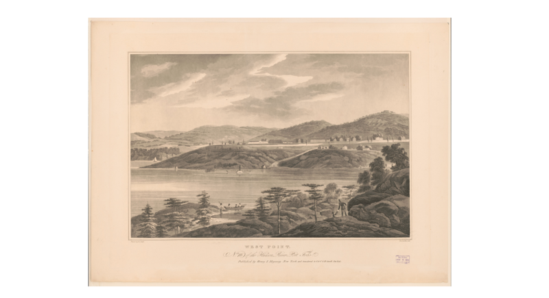
In September 1816, Claudius Crozet, an ex-captain of engineers in the French army, arrived at the West Point Military Academy in upstate New York to join the faculty as engineering professor. Educated at the École Polytechnique and the Metz School of Application, Crozet served in the French army during the battles of Borodino and Waterloo before resigning his commission in the wake of the Bourbon restoration. Crozet had been recruited by US agents in occupied Paris, including Sylvanus Thayer, who, after returning across the Atlantic in 1817, became West Point superintendent. The fledgeling academy had been drastically expanded in the wake of the War of 1812 to enrol 250 cadets on a four-year course. Crozet was brought in as a part of an effort to overhaul the methods of instruction and the curriculum on the model of the École Polytechnique and imbue a new generation of officers in the French school’s signature discipline – descriptive geometry.
It is one aim of my research on the development of the US central government in the nineteenth century to shift the focus from questions of ‘how much’ state – in terms of revenue, size or formal authority – and instead foreground no less valid questions regarding ‘what kind’ of state – in terms of the practices, techniques and knowledges that constituted the preferred means of governance. The criteria, explicitly or implicitly, used for identifying the ‘breakthroughs’ in the story of the American state – be it the Civil War, the New Deal, the Second World War – are usually based on the former. While historians have renewed our understanding of the nineteenth century state as much more powerful and proactive, it has been discounted on grounds of its statistical insignificance. But such accounts overlook equally important puzzles about how the techniques of statebuilding have shifted over time.
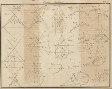
Crozet’s descriptive geometry is an example of how the work of governing was continually reconfigured through the transnational circulation of new scientific and technical practices. Initially developed by Gaspard Monge and his predecessors who taught at the École royale du génie de Mézières as a solution to the problem of defilading fortifications, descriptive geometry is the science of a mathematical characterization of three-dimensional objects in two-dimensional projections. It was a quintessential part of the ‘the Military Enlightenment’s’ program of harnessing science and mathematics to rationalise military practice and improve martial efficacy on land and sea. Its methods offered mathematical precision in an empirically grounded description of real-world objects ranging from landscapes and the natural terrain on maps to fortifications, machines and roads on project plans.
In creating this paper world of visual objectivity, design or planning of military works and operations was distilled from execution. Thus, it centralized command functions in the hands of planners. Through their detailed drawings, which took years of training to master, engineers could deploy soldiers in the field, command workers on the construction site or coordinate artisans in the workshop. In the wake of the French Revolution, Monge prioritized descriptive geometry in the curriculum of the École Polytechnique, teaching it to a generation of officers for the French army. If it was soon to be side-lined by analytical mathematics in the Polytechnique’s curriculum, however, Monge’s disciple Crozet placed descriptive geometry front and centre on the other side of the Atlantic. From 1816 onwards, it was taught for the first time outside the Polytechnique at West Point. Crozet initially lectured from his own notes before authoring the first work published in English in 1821 at the request of Secretary of War John C. Calhoun.
Descriptive geometry was taught to cadets in the second year, preceded by preparatory mathematics in the first year as well as lessons in drawing and French. After the course in descriptive geometry, the students deemed to have mastered it went on to apply it in years three and four in courses on topography, map-making, civil and military engineering in addition to the art of war. Crozet introduced new textbooks by Monge’s students, such as Sganzin’s Program D'un Course de Construction and Hachette’s Traité des Machines and Gayvernon’s Traité élémentaire d'art militaire et de fortification, which translated the general terms of descriptive geometry into specialized studies in strategy, tactics, fortification, bridge and road construction, mining and civil architecture.
Did it matter that more students (albeit a lot more) were now taking descriptive geometry classes? Those most adept at mastering it had newfound claims authority and power within the US military. A West Point degree was made a precondition of army commission and its graduates flooded the officer corps. Although West Point was founded in 1801, it’s graduates composed but a fraction of the officer corps during the War of 1812. After 1816, however, this changed rapidly. By 1820, academy graduates constituted 18 percent of the entire officer corps; 65 percent by 1830; and 76 percent in 1860.
Descriptive geometry came to pervade the management of war in the United States. Given the importance of the terrain to large-scale military operations during the Revolutionary and Napoleonic Wars, scholar Anders Engberg-Pedersen has written about how the topographical map became ‘a media a priori’ or prism through which the management of war was filtered (Empire of Chance, 2015, 8). Since the making and use of topographical maps, sketches and other forms of spatial knowledge were increasingly ‘rationalized’ as an application of descriptive geometry – as much as the design and making of fortifications, ordnance, and military plans – we could say that descriptive geometry signifies the import of such media technologies. By centralising control over planning and execution in their hands, its visual techniques empowered engineers vis-a-vis subordinates, lessening the need for discretion, training or judgement in subaltern officers and soldiers. Likewise, West Point professors argued that military engineers who knew descriptive geometry were best suited to high command because they could effectively judge the terrain at a mere glance and formulate appropriate strategies. Through the repetitive drilling at the blackboard, their ‘mental eye’ had been carefully curated to apprehend forms, distances and proportions, thus translating the chaos of the empirical world into legible geometrical figures that could be acted upon.
Crozet was only one among many French officers emigrating to the US, and Thayer only among the first in a long line of US officers who found themselves in Paris on official business in subsequent years. As observers, information-gatherers, advisors and even commissioned officers circulated across the Atlantic, these military reformers assembled an increasingly shared toolbox. It suggests that the US was more deeply enmeshed into wider transnational networks of resource mobilisation than often assumed, looking directly to other states (in this case, France) to provide crucial war-making resources.
Sveinn M. Jóhannesson received his PhD in history from the University of Cambridge in 2018. Currently, he is postdoctoral researcher at the Faculty of History, University of Iceland. Email: smj(at)hi.is. His first book, entitled The Scientific-Military State, is under contract with the University of Chicago Press.


